"One of the two ocean steamers leaves San Francisco every twenty days, running to the head of the Gulf of California, a distance from San Francisco of nineteen hundred miles. At the head of the gulf the passengers and freight are transshipped to four river steamers, and taken thence up the Colorado River to Yuma, one hundred and seventy-five miles, and thence portions are taken up the river to their several destinations. The river steamers make regular trips to Hardyville, three hundred and thirty-seven miles above Yuma, and five hundred and thirteen miles above the mouth of the river."
ARIZONA AS IT IS; THE COMING COUNTRY: Compiled From Notes of Travel During the Years 1874, 1875, AND 1876.
CHAPTER XVII: Colorado Steam Navigation Company. BY HIRAM C. HODGE (1877)
Years before the advent of steam and motor powered vessels, according to myths, legends, stories, fact and fiction, all kinds of waterborne craft had used the Colorado River north from the Sea of Cortez inland for one reason or the other. Explorers, pearl hunters, prospectors, conquistadors, pirates, mutineers, soldiers, even the Vikings and Chinese have all been alluded to as having accessed the river at one time or the other. There are even rumors that as late as 1944 a German submarine tried to navigate it. The modern era of using the Colorado begins in 1852, however the FIRST known attempt at navigation up the Colorado by ships that is fully documented and recorded happened a full 300 years earlier.
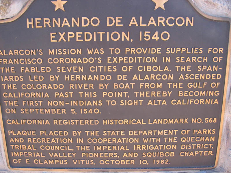
In 1540 AD, twenty years after the Spanish conquistador Hernando Cortez first landed in Mexico and militarily vanquished the region's powerful overlords known as the Aztecs, another Spanish conquistador, Francisco Vasquez de Coronado, headed north out of Mexico City with a full expedition under his command in search of the legendary Seven Cities of Cibola.
Coronado had a diarist or scribe, a chronicler if you will, by the name Pedro de Castaneda de N'jera that traveled with and recorded all aspects of the majority of the Coronado expeditions including explorations to the edge of the Grand Canyon and various lengths of the Colorado River.
At the same time Coronado marched north from Mexico City with hundreds and hundreds of armed men and horses, plus a 1000 Indian bearers, three ships left port on the Pacific side under the command of Hernando de Alarcon, loaded to the gills with additional stores and materials for Coronado's march. Alarcon sailed up the Sea of Cortez with all intentions of meeting up with Coronado --- without anybody of note fully realizing it wasn't likely to happen, not because the river was unnavigable in any way shape or form, but because the distance between the inland city or Cibola and the gulf continued to widen as Coronado's army marched north eastward.
When it was finally discovered the distance between the expedition and the gulf was becoming to great for Alarcon to ever meet up with the ground expedition, Coronado sent a captain under his command, Melchior Diaz on a scouting party toward the Gulf of California in search of Alarcon's three ships. Diaz, traveling basically west-south-west from Cibola and thinking he would eventually come to the gulf, and, although some reports have him arriving south of the delta he actually reached the Colorado River well over a 100 miles north the delta. He was told by Indians of the area that some days before, what they described as ships, had been seen on the river basically staying in the same location for two or three days. When Diaz reached the spot where the ships had been seen, he found a stash of supplies left by Alarcon who had sailed up the Colorado thinking he could meet up with Coronado. Alarcon, after waiting several days and with no sign of Coronado's army, offloaded the supplies, but if he had gone farther north searching for Coronado and returned to stash the supplies going back downriver or stashed the supplies and continued farther north or simply unloaded the supplies somewhere convenient and then turned around and went back is not clear.
The following paragraphs on the subject appear in Buddhism In America Before Columbus which, because the Spanish explorers continued to encounter hints or remnants of potential or possible Buddhist influence having been previously established in New Spain, covers much of the same material relative to the early historical European exploration of the Colorado River:
"The uncertainty of Alarcon's travels rests on the fact that he never got around to submitting the required formal report on his expedition. In lieu of the report he sent an exhaustive multi-page letter to the Viceroy of New Spain, Don Antonio De Mendoza, implying that the formal report would follow. If it did, it has never shown up in any archives or files that anybody knows about. Years later Alarcon's letter fell into the hands of an Italian, Giovanni Ramusio, who translated the Spanish of the letter into Italian and published it in 1556. In the letter are continuing references of days and days travel up the river.
"Complicating matters, overlapping endeavors along the Colorado River, Diaz and Alarcon just missed each other. So too, as fate with have it, before Diaz could return to Coronado's command he was severely injured in a freak accident wherein he fell from his horse onto his own lance, penetrating his thigh into his groin. He died 20 days later, and all before he too had written and submitted his formal report. So taken together, between Diaz and Alarcon there is a big unofficial blank on their travels.
"Because of Alarcon's return to New Spain and disappearance in the mist of time and the death of Diaz, Coronado's scribe Pedro de Castaneda de Njera did not get to interview each of them personally nor was he traveling with either contingent. He did however, because there was no formal report on the expedition, interview Diaz's men."
How far up river Alarcon traveled and where the location of the supplies were stashed is not known with any amount of certainty primarily because of insufficient archaeological evidence and the lack of the aforementioned formal reports. Where the supplies were unloaded and how far north along the river Alarcon sailed are not necessarily tied together, however. Lewis R. Freeman, in his book The Colorado River (1923), not talking about where the supplies were left, but how far Alarcon traveled up river, cites the work of Frederick S. Dellenbaugh who determined he got as far as the present day Blythe Canal 126 miles north of Yuma. He also cites Dr. Elliott Coues who felt that Alarcon was even farther north, 150 miles further north, reaching clear to where Needles, California is located, 282 miles north of present day Yuma. Freeman himself suggests that Alarcon offloaded his supplies somewhere along a 13 mile gap between the present day ghost town of Picacho located some 44 miles north of the Gila River and Lighthouse Rock, which is roughly 57 miles north of the Gila River, with Freeman really never getting into how far up river Alarcon may have really gone. However far Alarcon got up the river, unlike what was done in more recent times, he was charting new territory. There were no navigational maps or previous knowledge of the river such a depths, currents, or even where it actually came from. Everything was done on pure gut instincts and luck.
(for map of location click image)
HIDDEN AZTEC GOLD: THE LEGENDS OF THE LOST DUTCHMAN MINE
(please click image)
THE FOLLOWING EXCERPT IS FROM:
CHAPTER 1: History of the Colorado
THE STEAMBOAT ERA
The first known powered watercraft to navigate the Colorado from the Sea of Cortez arrived in Yuma on December 3rd, 1852. The "Uncle Sam", a 65-foot side-wheeler, brought 32 tons of freight from San Francisco. Piloted by Captain James Turnbull, it took fifteen days to get to Yuma. The Uncle Sam sunk in 1853, and freight transport reverted back to mule shipments from San Diego. In 1854, Captain George A. Johnson dismantled a steamboat in San Francisco, and had it shipped to the mouth of the Colorado where it was re-assembled. Propelled by a powerful 70 horsepower engine and with the advantage of a mere 30 inch draw, the 104-foot General Jesup sped up the Colorado to Yuma in 2-3 days, carrying 50 tons of goods.
The freighters required wood fuel, which wasn't in large supply in a desert. Wood yards needed to be spaced about a day's voyage (or about 30 miles) apart along the river, and fuel needed to be available there. The Cocopah Indians would cut wood from the nearby mountains and transport it to the wood yards. The first wood yard to be established was called Port Famine, but it and other wood yards along the river proved profitable for the Cocopah involved in the operation.
Captain Johnson had heard rumors that steamboats could get as far upstream as the mouth of the Virgin River, near present-day Las Vegas. Surmising that the forts and settlements of northern Arizona and Utah needed mail and supplies, and that water routes would get them there more quickly, Johnson talked Secretary of War Jefferson Davis into asking Congress for funding.
Jefferson gave the job to a relative, Lieutenant Joseph Ives. Ives had an iron-hulled stern wheeler named the Explorer built in Philadelphia and shipped to the mouth of the Colorado River by way of Panama in 1857. The Explorer was only 54 feet long, and had an unusual profile. There was a howitzer on one end and a cabin on the other, with its over-sized boiler in the middle.
Ives embarked on his expedition to explore the full limits of navigation on the Colorado on December 31st, 1857. Unbeknownst to Ives, Captain Johnson left Fort Yuma on the same day on the General Jesup, with the same goal. Johnson was peeved about losing the bid, and was determined to be the first to the Virgin River. He got as far as the first set of rapids about 75 miles south of the mouth of the Virgin River when, because of a shortage of supplies, the expedition was forced to turn around.
Meantime, the Explorer was proving no match for the powerful Colorado River current. It turned out to be under-powered, over-loaded, and susceptible to becoming grounded on sandbars. But the Explorer chugged along. A week after turning around, Captain Johnson and the General Jesup met the Explorer and its chagrined Captain, still plugging along upstream. The meeting was amicable enough, the crew members exchanging tobacco and information before the Explorer continued upstream. The Explorer actually got further upstream than the Jesup, finally running aground on a rock at the entrance to Black Canyon, which knocked the boiler off its foundation. Ives determined that Explorer Rock, which he named for the incident, was the practical extent of northern navigation on the river. In his official report, Ives concluded that steamboat navigation to the Virgin River might be possible during periods of high water.
For years Johnson operated only the two steamboats and freight began to stack up in Yuma. The situation was ripe for competition, and into the void stepped one "Steamboat Sam" Adams. The Esmeralda, a 93-foot sternwheeler, and the barge Victoria were built for navigation on the Sacramento River. The Esmeralda was smaller but more powerful than Johnson's boats, and could haul a combined payload of 100 tons. Adams had the Esmeralda and Victoria transported to the mouth of the Colorado. Despite the load, the Esmeralda steamed up the Colorado in record time. To keep pace, Johnson built the 135-foot Mohave, the most powerful boat on the river. The Mohave set a record of 10 days and two hours to navigate all the way to El Dorado Canyon, a distance of 365 miles.
The Southern Pacific Railroad reached the Colorado River in 1877. While the steamboats still had business, the railroad quickly became the transport method of choice. Johnson sold out to the railroad in 1878. Paddle-wheelers continued to feed the railroad for a period of time, but the construction of the Laguna Dam in 1909 closed the river to steamboats coming up the gulf from going any further than 14 miles north of Yuma.
Thirty-two years later, following the advent of a series of larger dams being built upriver from Laguna Dam, except for an unusual four year period 1942-1946, any sea-going access to the river from the Sea of Cortez disappeared because the river itself stopped flowing out into the gulf before it ever even reached the end of the delta.
THE STERN-WHEELER COCHAN, COLORADO RIVER, YUMA AZ, CIRCA 1900
HOOVER DAM, PARKER DAM, IMPERIAL DAM, ET AL
Construction of Hoover Dam began in 1931 and officially dedicated by President Franklin D. Roosevelt on September 30, 1935. Lake Mead, the lake behind the dam, began filling February 1, 1935, eight months before the dedication and four months before the last of the concrete ceased being poured.
Even though it took until 1941 for Lake Mead to "fill up," by the second half of 1936 water had reached a high enough level to permit power generation. By March 1937, four generators were operating full time on the Nevada side with the first Arizona generator in operation by August. By September 1939, all of the generators planned to be installed on both sides of the dam were operating at full capacity.
During the six year period it took for the lake to fill, combined with the construction of Parker Dam 155 miles downstream and the Imperial Dam further south, for all practical purposes, below all three dams, the river stopped flowing, impacting adversely the esturary and causing a silting in of the river exit to the gulf.
By 1939 with all the generators at Hoover Dam up and running at full capacity accompanied by the necessary increase in required water outflow, albeit nowhere near the flow prior to the dam being built, with cooperation of Parker and Imperial, the river began slightly flushing the delta. In 1941 the Hoover Dam spillways were first tested then opened for a year, releasing an additional water surge downstream. The following refers to opening the spillway gates:
"August 6, 1941, soon after the reservoir level had reached a maximum elevation of 1220.44. The drum gates were raised for several hours on August 14, 1941, and a hurried inspection revealed that the tunnel lining was intact, and the inclined portion showed little or no signs of erosion at that time. Operations were then continued without interruption until the reservoir level had been lowered to elevation 1205.60 on December 1, 1942."
(source)
During the six years while the lake filled, except for a relative minor influx here-and-there from the Gila River just below the first fully operational concrete dam on the river, Laguna Dam (completed 1905), little or no water made it very far down the delta and eventually it basically turned into an almost concrete-like hardpan. The main channel to the gulf all but disappeared along with any water in it, the river basin turning into a former shell of itself and vanishing before ever reaching the Sea of Cortez.[1]
Shortly after the additional water needed to operate the generators began to flow, combined with the release of the spillway water things began to change. Then on September 19, 1941, just at the mouth of the Gulf of California, two strong tropical storms merged together and formed a huge intense hurricane that now days would be classified as a Category 5. A ship caught in the eye of the hurricane reported a rapidly-falling pressure 27.67 inHg while they were still able to measure it --- translating into winds well over 150 mph, creating a storm surge of 18 feet and between 7 and 12 inches of rainfall. The hurricane rushed up the center of the gulf pushing the 18 foot storm surge in front of itself, eventually roaring inland like a tidal wave as it hooked to the northeast after entering the bottom of the delta. Then miles inland it ran out of steam and the water, forced into a V and with the addition of the storm's continuously pounding rainfall, began retreating backwards toward the gulf over the path of easiest resistance, basically retracing the old river channel and while doing so flushing it out.
Two years later, on October 9, 1943, one of the strongest hurricanes to ever hit the Mazatlan area slammed into Mexico just south of the city with sustained winds of at least 136 mph and a pressure of 28.31 inHg. The hurricane destroyed close-by towns and half of Mazatlan, killing around 100 people, injuring 102, and leaving over 1,000 homeless. The storm surge was not nearly as intense as the 1941 hurricane and it began quite a bit farther south, however it still pushed north and crossed over the delta and up the river. Everyone says so what, tropical storms and hurricanes had been impacting the river exit and the north end of the gulf on and off for centuries. The thing is, the six years the dams hindered the river's outflow to the gulf was the first time in recent history that the Colorado river water had not reached the gulf. Both hurricanes pushed tons of water up a dry, flat, concrete-hard surface wedged at the north end where remnants of the old river channel remained. When the surges ran out of power, and focused at the top of the wedge, all the water drained under gravity back toward the gulf basically following the original main channel.
Thus, because of the opening of the spillways at Hoover Dam combined with two powerful hurricanes, especially the one in 1941, for a brief several year period (1942-1946) access from the gulf to at least the Laguna Diversion Dam was once again possible. After that things returned to closer to how it had been when the lakes were being filled. However, in 1983 flood conditions occurred at Hoover Dam and the spillways were once again opened. That 1983 downstream outflow contributed significantly to flushing out the river and a new brief access period from the gulf.[2]
-----
THEN_____________________________________________NOW
LAGUNA DAM COLORADO RIVER
EARLY COLORADO RIVER STEAMBOAT LANDINGS
FROM THE DELTA TO THE VIRGIN RIVER
DESERT SHIPS, SPANISH TREASURE, AND COLORADO RIVER FLOODS
SEE ALSO:
VIKINGS OF THE DESERT SOUTHWEST
THE NAZI PLOT TO BLOW UP HOOVER DAM
GERMAN SUBMARINE ATTACK ON HOOVER DAM
THE GREAT GOD PAN
HISTORY OF SHIPS ON THE COLORADO
CHAPTER 1: History of the Colorado
STEAMBOATS OF THE COLORADO RIVER
CHAPTER XVII: Colorado Steam Navigation Company
THE CONQUISTADORS LOST TREASURE OF THE GRAND CANYON, SEA HUNT, OCTOBER-DECEMBER 1961 #11 ---
(please click either image)
LOST SHIP OF THE DESERT, UNCLE SCROOGE COMICS, SEPTEMBER 1954 ISSUE #7
----
----
(please click any image)
SHIP IN THE DESERT, GENE AUTRY COMICS, JUNE 1951 ISSUE #52
-----
----
(please click any image)
THE DESERT SHIP: A LEGEND OR TWO. THE WESTERNER, DECEMBER 1950 ISSUE #31
--
--
(please click any image)
SO, WHERE DOES A LOT OF THE ABOVE COME FROM?
IT FLOWS FROM THE SUPER HEAVILY INJECTED ACADEMIC BACKGROUND BRIMMING
WITH IN-DEPTH ENCYCLOPEDIC AND INTELLECTUAL KNOWLEDGE OF INFORMATION
AND DATA, ALL COMING FROM COMIC BOOKS OF COURSE. TO SEE CLICK THE IMAGE.
THE WANDERLING
(please click)
As to the subject of donations, for those who may be so interested as it applies to the gratefulness of my works, I invariably suggest any funds be directed toward THE WOUNDED WARRIOR PROJECT and/or THE AMERICAN RED CROSS.
FOOTNOTE [1]
The river not reaching the gulf over a sustained period of time was not a totally unusual event, it was just the first time it was caused by man --- and the effects of that action still linger. Historically over the centuries nature changed the course of the river any number of times, AND typically much more drastically. The following paragraph, from the source so cited, says it best:
In the distant past, the Gulf of California, which the Colorado river flows into, extended 150 miles further inland from its present shore. There it formed a large bay that was 50 miles wide. Each year the river deposited over 140,000 acre feet of silt at the rivers delta. This is enough to cover 214 square miles in 1 foot of soil. Eventually these accumulated deposits grew so thick as to seal off the upper portion of the gulf. Cut off from the river, the water that remained formed a huge lake eventually named Lake Cahuilla. When the Colorado flooded, its waters would spill into this lake. Over time, flooding, local run-off and evaporation made this a salt water lake.(source)
CLICK IMAGE TO SEE THE FORMATION OF LAKE CAHUILLA
- 700 AD: Lake Cahuilla arises in the Salton Sink when the Colorado River silts up its normal egress to the Gulf of California and swings northward through two overflow channels. Lake is subjected to wet and dry climatic cycles over intervening years, filling up and drying out four times.
- 700 AD: Riverine tribes along present day eastern Imperial County border practice farming. Presence of lake is an attractive addition to their annual round of domestic economics. After planting seeds and kernels in the Colorado floodplain, they cross the Imperial dunes to exploit the lakeshore and return home for summer harvest.
- 1500 (about): A large inflow of water from the gulf fills the lake to a body of water 26 times the size of the current Salton Sea. Its former water line is still visible on the nearby mountains.
- 1539 Cortez dispatched Francisco de Ulloa to explore the northern coast of Mexico. Ulloa left with three ships on July 8, 1539 entering the Gulf of California six weeks later, naming it the "Sea of Cortez," reaching as far north as the delta before returning south. One ship was lost or destroyed in a storm and with the other two in need of repair Ulloa holed up, resuming the voyage on September 12, traveling up the outside of Baja Peninsula on the western coastline as far as the Isla de Cedros. Sources differ about what happened after that. Some reports say Ulloa returned to Mexico, but stabbed to death. Other reports say his ship was lost without a trace during the return voyage, swept inland in the gulf by a huge tsunami, later becoming known as the Lost Ship of the Desert.
- 1540: Colorado River delta first explored by Spanish. Melchior Diaz journeys up the mouth of a river now known as the Colorado from the gulf and sends expeditions from the river to present day Imperial Valley.
- 1604: Don Juan de Ornate, Spanish Governor of New Mexico, explores the river that he names the Colorado.
- 1700-1750: Last large infilling of Lake Cahuilla occurs.
- 1774: Don Juan Bautista de Anza leads the first large European party through what is now the Imperial Valley on the way to missions of San Gabriel. Salton Sink is a dry lake bed again.(source)
And now this:
- 900-1100 AD: The Seri Indians of the Gulf of California's Tiburon Island have a curious legend they still tell of what they called "Came-From-Afar-Men." They landed on the island in a "long boat with a head like a snake." The light-skinned men reportedly had yellow hair and beards and had a woman with red hair traveling with them. Their chief stayed on the island with the redheaded woman while the rest of the men hunted whales in the Gulf. When they finished their hunting, after hearing of a great body of water to the north, they boarded their ship and sailed up the Gulf never to be seen again.(source)
- 1540: As found in VOYAGES: l'Histoire de la Dcouverte de l'Amrique, Vol IX, Henri Ternaux-Compans (1836):
"Through the great canyon a large river flows from the north to the south and falls into the northern end of the Gulf of California. Now, in the useful translations of the Spanish authors of 1540 AD we find that the scribe of the Conquistadors placed near the Colorado River, in a small island, a sanctuary of Lamaisra, or of Buddhism. He mentions a divine personage living in a small house near a lake upon this island, and called, as he says, Quatu-zaca, who was reputed never to eat."
(source)
In 1901, John Fryer (1834-1924), an eminent Professor of Oriental Languages and Literature at the University of California at Berkeley wrote an article titled The Buddhist Discovery of America a Thousand Years Before Columbus, that was published in the July 1901 issue of Harper's Monthly Magazine page 256. In the article Fryer wrote the quote below that is heavily related to and influenced by the quote above as attributed to Henri Ternaux-Compans (1836) wherein Compans writes about the scribe of the Conquistadors placed near the Colorado River, in a small island, a sanctuary of Lamaisra, or of Buddhism. Fryer mentions a divine personage living in a small house near a lake upon this island:
"A deified priest or lama, who is said to have lived on a small island near the Colorado River, had the name of Quatu Sacca which seems to combine the two names Gautama and Sakhya."
The island so mentioned by both Compans and Fryer and said to be a sanctuary of Lamaisra or of Buddhism inhabited by a deified priest called Quata-zaca, is Cottonwood Island, now submerged by Lake Mohave. The Buddhist sanctuary had been established hundreds and hundreds of years before the Vikings ventured up the Colorado. We know that to be the case because ancient Chinese documents record that circa 489 AD a Buddhist monk named Hui Shen with a few other monks traveled south along the California coast in ships from China, then after disembarking near where Port Hueneme is today (see map below) cut inland 300 miles across the desert using Native American trails to the Colorado River.
-----
THEN-----------------------------------------------------------------------NOW
COTTONWOOD ISLAND
ON THE LEFT OF THE MAP IS THE WORD CHUMASH. ABOVE THAT SANTA CLARA R. AND A DOTTED LINE LEADING
TO SOLEDAD PASS THEN TO MOJAVE RIVER. THAT IS THE BASIC ROUTE USED BY HUI SHEN TO THE COLORADO.
FOOTNOTE [2]
-------
LEFT PHOTO SHOWS HOOVER DAM IN 1983 AT CAPACITY. PHOTO ON RIGHT SHOWS DAM CIRCA 2016
On page two of "Colorado River Flood of 1983," linked below, there is a chart titled History of Colorado River Flooding that graphically shows the years of the amount of Colorado River flooding from 1905 through to 1980. Up until Hoover Dam was built, there was nothing but year after year of major flooding. After the dam was built although there was minor flooding, there was, for the most part, nothing but a major significant drop off of any major flooding --- except for, as the chart so graphically shows between the years 1941 and 1943 --- the highest level of flooding ever reached on the river, actually twice as high as the next highest, after Hoover Dam was built until the dates run off the chart in 1980. The dates of the flooding coincides perfectly with the later access of the river I've cited in the main text.
COLORADO RIVER FLOOD OF 1983
LAGUNA DIVERSION DAM
NEARLY FLAT 4780 FOOT SPILLWAY AS SEEN AT RIVER LEVEL
GERMAN SUBMARINE ATTACK ON HOOVER DAM
As found in the above link, the alleged wartime attack against Hoover Dam by a rocket launching equipped German submersible just happened to coordinate with the exact same years that the river reached its highest full-length depth level since before the dam was constructed. As a reminder of the extent of that flooding, the following quote is re-presented from the above:
"Up until Hoover Dam was built, there was nothing but year after year of major flooding. After the dam was built although there was minor flooding, there was, for the most part, nothing but a major significant drop off of any major flooding --- except for, as the chart so graphically shows between the years 1941 and 1943 --- the highest level of flooding ever reached on the river, actually twice as high as the next highest, after Hoover Dam was built until the dates run off the chart in 1980. The dates of the flooding coincides perfectly with the later access of the river I've cited in the main text."
Although the submersible would not have been able to have traversed the river any farther north than Laguna Dam anyway, the dam was selected as the spot where the sub was dismantled for two reasons. First was the design of the dam itself and the outcome of that design through to it's actual physical completion. It was built unlike any other dam on the river ever or since. The design and how it was constructed was absolutely perfect for easily pulling a submarine or any other craft out of the river and being able to dismantle it. For one thing, Laguna Dam was actually a diversion dam. It diverted the water of the river to the sides to smaller dammed channels that redirected or diverted the water from it's normal downstream flow into the channels. To accomplish the task a 4780 foot long nearly flat concrete spillway was built stretching clear across the river bed from California to Arizona and back. The upper portion or the top of the spillway, that is, facing the down flow of the river, was barely above the top-out level of the river's normal flow. The downstream side, because of the almost airstrip like 150 foot wide spillway and the slight down-angle slope, the edge was only just submerged as it reached the water. As you can see from the graphic above it would be almost like working on concrete airstrip, easily conducive for pulling out, dismantling, loading, and transporting.